Overview
The Department of Community Development is conducting a Sea Level Rise (SLR) Vulnerability and Risk Assessment that will identify potential losses or damages from flooding due to sea level rise.
With more than 200 miles of marine shoreline, the County is already
experiencing hazards due to rising sea levels as coastal erosion, flooding, and inundation pose increasing risks to public and private infrastructure, public health, and safety.
The assessment will characterize the risk of loss, and highlight areas of the community, resources, infrastructure, or assets considered most vulnerable.
The assessment will be used for a variety of planning purposes. It will inform future revisions to the County’s shoreline master program, critical areas ordinance, public
works transportation improvement program, wastewater systems, storm water capital facilities plan, and Comprehensive Plan.
Outreach efforts for the SLR Vulnerability and Risk Assessment will include consultation with Tribal partners, non-government organizations, businesses and industries, and community or neighborhood groups throughout the assessment process. This grant funded project must be completed by
June 2025.

This project is being funded under a Shoreline Planning Competitive Grant received by the State of Washington Department of Ecology under Grant Agreement No. SEASPC-2325-KiCoCD-00014.
What is sea level rise?
Sea level rise refers to the gradual increase in the average height of the world's oceans. This rise is driven by two key processes:
Melting Ice Sheets and Glaciers: Ice sheets and glaciers, particularly in Greenland and Antarctica, are melting at accelerated rates, adding large volumes of freshwater to the oceans.
Thermal Expansion: As ocean water warms, it expands. This expansion contributes to the overall rise in sea levels.
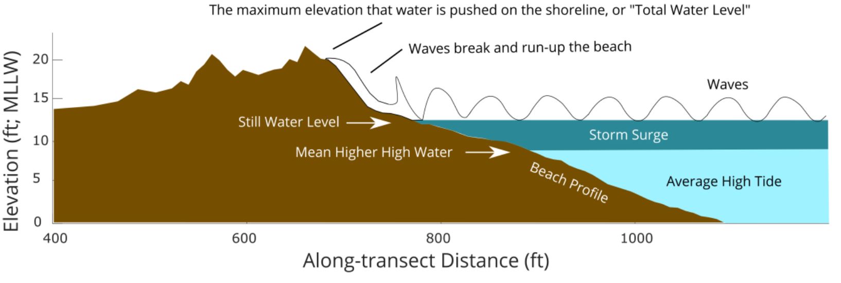
These global processes are also affected by local factors, resulting in relative sea level rise—the change in sea level relative to the land at a specific location. Relative sea level rise considers both global ocean level changes and local factors such as land subsidence. These processes are further influenced by localized natural variations in ocean currents, wind patterns, and gravitational effects. In Kitsap County, these combined factors can cause sea levels to rise differently compared to other regions, with impacts compounded by storm surge, wave runup, and atmospheric pressure changes during storm events, leading to unique local impacts that require careful assessment and planning.
 A schematic view of coastal water level during a hypothetical storm event.
(Miller et al. 2019. Extreme Coastal Water Level in Washington State: Guidelines to Support Sea Level Rise Planning.)
An ArcGIS StoryMap and Web Map have been developed and will continue to evolve throughout this project. These applications are intended to provide easily accessible platforms for residents to gather information on sea level rise projections, methodology and resources, view the results of the mapping efforts and potential adaptation strategies to mitigate impacts of rising sea levels and flood events.
If you have any trouble viewing features in the Web Map, please Refresh (Ctrl + R) the application.

Assessment Process
The Sea Level Rise Vulnerability and Risk Assessment follows a systematic approach to ensure comprehensive evaluation and planning. Key tasks for the assessment will include:
Developing Methodology: The project begins by creating a robust methodology to assess vulnerability and risk, which involves defining flooding and sea level rise inundation scenarios based on the best available science.
Collecting Baseline Data: The project team will collect baseline data on current conditions and inventory vulnerable critical facilities and infrastructure.
Risk and Vulnerability Mapping: Using GIS-based models, detailed maps will be developed to illustrate areas at risk of flooding and sea level rise inundation within designated timeframes and levels of confidence (e.g., 1%, 50%, and 90% degree of certainty). These maps highlight critical infrastructure and assets most vulnerable to these changes.
Policy and Regulation Review: An audit of current policies and regulations will identify gaps and opportunities for updating the County's development policies to better address impacts from coastal flooding and sea level rise planning scenarios.
Reporting: Findings from data collection, mapping, and policy audits will be compiled into a comprehensive report. This report includes recommendations for adaptation strategies and next steps for the County to mitigate risks associated with sea level rise.
Assessment Timeline
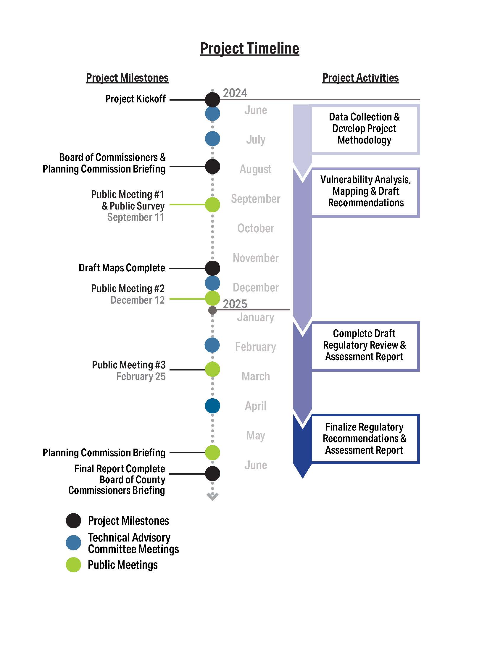
The Sea Level Rise Vulnerability and Risk Assessment kicked off in June 2024 and will be completed by June 2025. The project timeline includes the following phases:
Summer 2024: Initial focus on data collection and developing the project methodology.
Fall/Winter 2024: Mapping and vulnerability analysis, along with the development of initial recommendations.
Winter/Spring 2025: Conduct regulatory review and prepare preliminary report and draft audit summary.
Spring/Summer 2025: Finalizing recommendations and completing the final report.
Throughout the process, there will be several key touchpoints with the Board of County Commissioners, the Planning Commission, the public, and a Technical Advisory Committee. These interactions will help inform project inputs and recommendations.

Public Engagement
Public involvement is a critical component of the Sea Level Rise Vulnerability and Risk Assessment. The project will provide multiple opportunities for community input, including:
Public Meetings: Multiple online and in person meetings are planned throughout the project for the public to provide feedback on the inundation maps and assessment results.
Briefings: Briefings will be held with the Board of County Commissioners and the Planning Commission to keep them informed and gather their input at critical decision points.
Survey: A public survey is expected to be released in September at the public meeting. This survey will seek feedback from residents throughout unincorporated Kitsap County, asking the community to provide input on public assets to be included in the assessment and help the project team identify areas of known flooding.
GIS Applications: An ArcGIS StoryMap and a Web Map have been developed and will continue to evolve throughout this project. These applications are intended to provide easily accessible platforms for residents to gather information on sea level rise projections, methodology and resources, view the results of the mapping efforts and potential adaptation strategies to mitigate impacts of rising sea levels and flood events.
To keep up to date with the project,
sign up for project updates and look out for notifications through email, social media, and flyers for details on upcoming meetings and events.
DATE
|
Meeting Type
| Materials
| Video
|
June 14, 2024
| Technical Advisory Committee
| Agenda
Notes
Presentation
| 
|
July 15, 2024
| Technical Advisory Committee
|
Agenda
Notes
Materials
Presentation
| 
|
August 19, 2024
| Board of County Commissioner Briefing
| Presentation
Community Engagement Plan
|
|
August 20, 2024
| Planning Commission Briefing
| Presentation
Community Engagement Plan
|
|
September 11, 2024
| Public Open House, Hybrid Commissioners Chambers
| Agenda
Presentation
Activity Posters
North Map
South Map
Q&A
| 
|
December 4, 2024
| Technical Advisory Committee
| Agenda
Presentation
| |
December 12, 2024
| Public Open House, In-Person, Kingston, Village Green Community Center 6:00 - 7:30
| Agenda
Presentation
Activity Posters
Inundation Area Maps:
Chico
Gorst
Hansville
Holly
Kingston
Olalla
Port Orchard
Seabeck
Silverdale
Southworth
Suquamish
Waterman
|
|
February 19, 2025
| Technical Advisory Committee | Agenda
Presentation
|
|
February 25, 2025
| Public Open House, Hybrid
Greater Hansville Community Center, 7:00-8:30pm
| Public Notification
Presentation
| 
|
June 17, 2025
| Public Meeting, Hybrid
Kitsap County Planning Commission, 5:30pm
| Presentation
Draft Final Report
| 
(start at 8:00 min)
|

