The purpose of design standards is to guide the general character and the look and feel of a designated area, this includes: structures, landscaping, signage, etc.
Standards are baseline requirements for the design of development projects. Some guidelines are recommendations that are intended to further define the desired character of development within the districts.
Typically projects are designed from the requirements of Kitsap County Code, Title 17 Zoning (Title 17.420.050) if your parcel is within one of Silverdale's design districts you will also need to follow the standards described in the design guidelines. If there is a conflict in requirements the more restrictive will apply.
These design guidelines present and describe overall urban design intent for Silverdale as a compact, diverse, mixed-use urban center. The guidelines use “unique (special) amenities” of Silverdale as a foundation for design intent and actions, organized in nine districts to focus on physical amenities and features specific to each district.
The Guidelines provide as much detail as possible by district to guide development that is compatible with existing development patterns, incorporates unique or special features, or influences a significant change in those patterns. The methodology is more complex by intent. It requires extra effort from all stakeholders to assure the implementation of a compact pedestrian-friendly and safe downtown.
The Silverdale Design Guidelines are composed primarily of Community Design Guidelines—the larger scale design principles that address overall development patterns, circulation, building configurations as well as mass, bulk, height, landscaping and setbacks and the Standards that implement the Guidelines. They address how districts relate to one another and the entire downtown, pedestrian and vehicular connection and circulation, and overall design composition within each district.
Mandatory vs. Interpretive Standards/Guidelines
Mandatory refers to the obligatory application of design guidelines and are commonly referred to as standards. The words "will," "must," and "shall" indicate a mandatory standard.
Interpretive refers to a translation of a design intent, where a variety of conceptualizations is possible and may require more flexibility in implementation. Words such as "could," "can," and "should" indicate a preference, but not a requirement.
To help you find your design district,
click here or on the map below
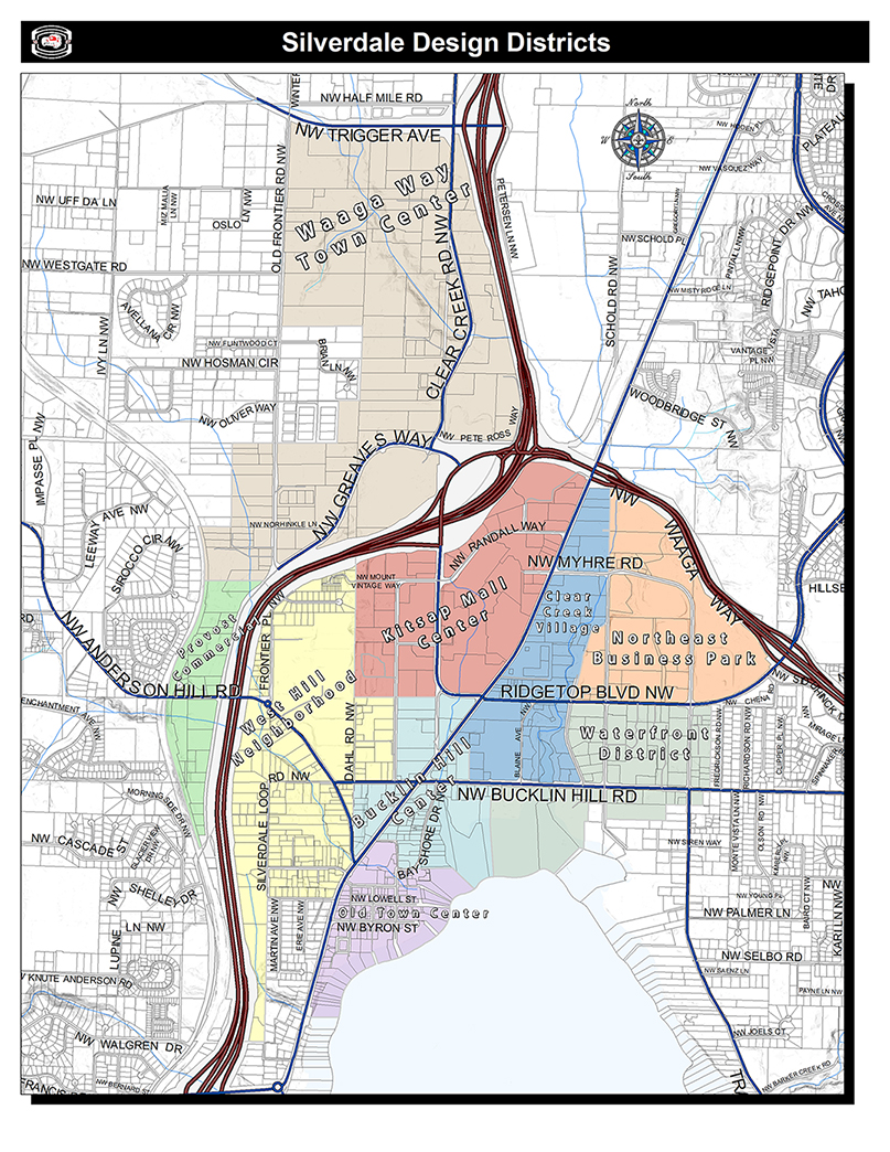
Historical development occurred in Old Town and south of Bucklin Hill Road along Silverdale Way prior to the expanded shopping center development to the north. Bucklin Hill Center, the area around the intersection of Bucklin Hill Road and Silverdale Way, is both a design district at a major intersection and a gateway area into the larger downtown Silverdale area. |
Clear Creek Village extends north from Bucklin Hill Road to State Highway 303, excluding the northeast portion of the Bucklin Hill Road/Silverdale Way intersection, and from Silverdale Way eastward to and including eastern portions of the Clear Creek corridor. Clear Creek Village is comprised of a riparian area, a north-south greenway forming a natural "V" shape through the center of the Silverdale commercial center. Medium-sized, one-story shopping center/plazas with front yard surface parking lots, capable of being reconstituted as mixed-use centers are the existing development pattern. Silverdale Way is the western boundary of the super blocks north of Bucklin Hill Road to State Highway 303. Significant east-west depth of super blocks from Silverdale Way to Clear Creek provides a potential development amenity for residential units located along the creek corridor and away from arterials
|
Kitsap Mall is a regional shopping center with an enclosed pedestrian concourse and significant open space in the form of surface parking lots adjacent to the mall. The center borders the west edge of Silverdale Way for approximately 1,200 feet, presenting an opportunity for future building and landscape design that can relate directly to Silverdale Way and Clear Creek Village
|
The Northeast Business District includes Clear Creek and associated riparian area and wetlands. The district has views of Dyes Inlet and encompasses lands to the south of Highway 303. The predominant development pattern is office park, commercial and "big box" retail between Ridgetop Boulevard and Highway 303, with some high-density housing to the east.
|
Old Town’s physical identity is different from the remaining portions of Silverdale. Old Town’s physical identities include:
• Block grid street pattern, 200 feet by 300 feet, two way vehicular movement. • Older one to two story, small-scale commercial and office building types with little or no front yard setbacks. • Dyes Inlet, shoreline, waterfront parks and views of Inlet. • Strawberry Creek and riparian area. • "Silverdale Creek," an underground drainage channel that emerges from a culvert southeast of the Bucklin Hill Road and Bay Shore Drive intersection. • Linder Field. • Older, small-scale residential buildings on small blocks with landscaped front yards. • Older churches and public/semi-public buildings throughout Old Town
|
Commercial area west of Highway 3 and south of Anderson Hill Road.
The neighborhood’s natural and physical features include large forested areas and moderate to steep slopes with views of downtown Silverdale and Dyes Inlet.
|
Waaga Way Town Center
The Waaga Way Town Center includes land that is largely undeveloped and underutilized. The district is located northwest of the Highway 3/303 interchange in Silverdale. The predominant development pattern is single family residences with existing commercial development along Provost, Old Frontier and Clear Creek Roads.
The neighborhood’s natural and physical features include large forested areas, isolated wetland systems and moderate to steep slopes with views of downtown Silverdale and Dyes Inlet
|
The Waterfront District is a mixture of established multi and single-family homes south of Bucklin Hill Road and east of Mickelberry Road and commercial development north of Bucklin Hill Road. Properties adjacent to Bucklin Hill Road and near Dyes Inlet enjoy partial views of Dyes Inlet and the Clear Creek corridor |
The neighborhood as a whole has views to the eastern wooded slopes and Dyes Inlet and is bounded by Highway 3 to the west and north. A wooded slope runs north/south generally along the west side of Silverdale Way and Randall Way.
Currently, academic facilities share the hill with residential uses to the north of Strawberry Creek and Silverdale Loop Road. Medium density housing exists along the eastern edge and slope of the neighborhood.
The neighborhood’s natural and physical features include Strawberry Creek and a forested ravine between Munson Street to the south, Silverdale Way on the west, Silverdale Loop Road on the north and Anderson Hill Road on the west
|
